Showing posts with label Cherry Hinton. Show all posts

Tuesday, 4 April 2017

Back Out on the Hildersham Circuit


Contents

Intro

So, I work outdoors with bikes. Yee haa! Lucky me!

However, this isn't all the roses and happiness it can be. Sadly, over the winter term, I'm really rather reticent to spend my weekends going outdoors very much. Whilst friends are shooting off for a good time in fields and on tracks, I'm sat there going "No thanks, just done that for the past five days".

Then Spring comes along and all that "stay in" feeling disappears. This weekend was very much that time. The blooms where blooming and the blossom, er, blossoming. It was time to be outdoors on my bike for the fun of it!

I usually end up on a simple 20 mile circuit to the south of Cambridge. Luckily, there's plenty of decent off-road routes, bike paths, and (at worst) quiet roads. I get down as far as Hildersham on my way dropping through Cherry Hinton and Fulbourn on the way there, then Abington and Babraham on the way back, This time, I had the new Babraham Institute path in mind, rather than Stapleford and Shelford. It's more direct and I wanted to find out what it was like.

Map


So the clip starts near the station on Hills Road (and ends in the same place!) and heads out through Cherry Hinton. The first bit shows how poor the station area has become with the new development. The cycle bridge is a welcome removal from that poor environment taking us over to Romsey Town and then on to the pleasantries of The Tins. A final wiggle through Cherry Hinton and we're on the cycle route to Fulbourn.


Path from Marmora Street


The Tins

After Fulbourn, it's up into the hills. Well, what counts for hills in these parts. They are still very pleasant with lots of people enjoying the outdoors, with all kinds of animals! The roman road of Worsted Street affords a great route south with stunning views over the landscape. Small hillocks dot the landscape, along with the odd majestic wind farm.


Daffodils south of Fulbourn


Horses on a Walk


Woody Worsted Street

Hildersham is a delightful little village, with a pretty bridge (and ford for over 12 tons) at the centre. And then the Pampisford Road round behind Abington towards Granta Park, which is pleasant enough. Then, a short section of unpleasant road, often with 1 or 2 cars only but doing 70mph, sometimes far too clsoe for no reason gets us to the footbridge over the A11.


Hildersham Bridge


A11 Bridge

And this is the one weak link here. It's a "converted" footbridge. It's a long distance up and down on very steep metal tracks. Not something I can do with a normal commuting load. The down section is just as difficult, as I can't brake even with walking the bike. I was working nearby recently, and simply had to drive because this isn't a choice when commuting. And sorry too that this blocks cargobikes, different ability bikes, young and old people, and anyone that can't hold onto a lot of weight.


A11 Bridge Path

Once in Babraham, turning left towards the Institute entrance felt odd, I'm used to heading to Sawston. Avoiding the narrowed spaces near the school is good though. And it's into the Institute!

I've done this in more detail here. The funny little start section is possibly good, not quite sure. I'd think it adds to the option if traffic is backed up on the main road, but does lose the priority as you come back out again. Then I was a little concerned about where to go. There were bike symbols on the road, but people ride into the Institute itself so didn't give me a strong feeling of going in the right dirction. Then, a sign appeared in the distance and helped guide across a rather odd "Stop" line and onto the path itself.


Babraham Institute Entrance


Access to Babraham Institute Path

The path was open, smooth, and thankfully not absolutely straight. It's not near trees, so root damage is unlikely. The park is quite pleasant to ride through and there's plenty to look at. Changing angles regularly helps that as well as to stop the boredom sinking in of constantly going in exactly the same direction.


Tree on Babraham Insitute Path

At the end, the route out to the cyclepath over the Magogs seems sensible. You have to cross the A1307 and having it just a few metres form the roundabout is fine. There is a central refuge, and thankfully it's not staggered the way town street designers get wrong.


Exit from Babraham Insitute Path

The path over the Magogs is, well, next to a busy road. It's pleasant enough when a Sunday, not quite sure how it'll be on a weekday. And, from this direction, it feels like quite a way up! It's really not very far up, totalling 45 metres, it's just it starts about a mile out and slowly ramps up. It feels like it's gone on for ages! Still, it's next to pleasant beech woods for the steeper second section. And also, there's all that potential energy to release on the way down!


Bench at theTop of the Magogs

Finally, the route into Cambridge has it's pros and cons. Whilst it's a good route as you start to come into town, you suddenly have to switch sides. Although there's a section around 200 metres long with cycle routes on both sides, it's just not long enough to find a gap. Getting onto the new Hills Road Cyclepath is great, although there's no guarentee it'll be clear, and you have to mix it again at the bridge.


Floating Bus Stop


Video

And here's the clip (music warning!) with a variety of start points which open YouTube in a separate window.
Go HD see * at bottom

At the start
00:32 Cycle Bridge
00:57 Marmora Path
01:07 The Tins
01:40 Cherry Hinton High Street
01:58 Fulbourn Cycle Path
02:27 Fulbourn
03:05 Babraham Road Avenue South
04:07 Worsted Street
05:01 Crossing the A11
06:15 Path to Hildersham (stunning views)
06:50 Hildersham
07:12 Crossing the A1307 to Pampisford Road
07:36 Abington
08:05 Granta Park
08:20 A11 Footbridge
09:00 Entrance to Babraham Institute
09:30 Crossing the A1307 to Cyclepath
10:39 Top of the Magogs
11:16 Back into Cambridge
11:49 Hills Road Cyclepath


The music is in sections too, all from the Film "Moulin Rouge" and they roughyl follow different areas of the video.

00:12 Sparkling Diamonds, getting out of Cambridge and through Fulbourn to open country
03:05 Spectacular Spectacular, riding up into the hills
04:12 Because we Can, riding along the off-road section and back towards Cambridge
07:40 Bolero, the Institute path and steadily getting back into Cambridge


* How to go HD.


Friday, 27 January 2017

Exam Questions


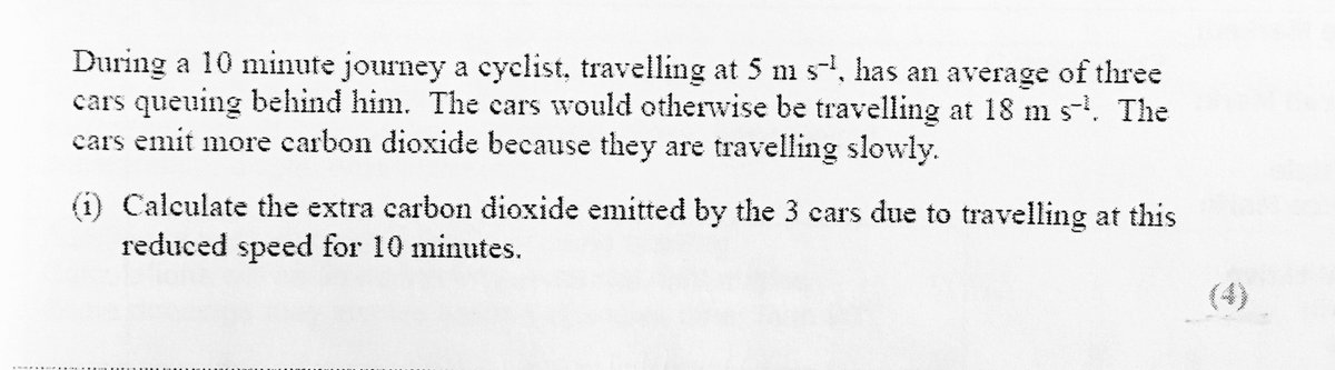
So, AdExcel put a series of questions into an exam paper that are designed to imply people cycling cause pollution. Here is the central quesion, but there is more to it here.


The premise seems reasonable, until you think for about a millisecond. Wait, during a ten minute journey there's an average of 3 cars behind? No, sorry, not in any world I've ever experienced!

So, I thought we'd take a look at something that looks like reality a bit more. Here's a clip from a morning this week, showing traffic coming through Cherry Hinton into Cambridge.

And here's the clip with a variety of start points which open YouTube in a separate window.
Go HD see * at bottom

At the start
0:42 From Perne Road
1:56 From Cherry Hinton High Street


So we'll start with some simple questions.
1. How many people riding bikes are holding up this queue of cars?
2. How many people driving cars are holding up other people driving cars?
3. How many cars are single occupancy?

And some answers, so those hard of analysis capabilities (like maybe some AdExcel exam setters) might keep up.
1. I'm hard pressed to spot a single rider holding anyone up here. The clip shows over a mile and a half of queuing traffic, without many people riding at all. And where there is the odd rider they aren't interacting with motor traffic at all.
2. Pretty much all of them.
3. The figure for rush hour traffic in Cambridge is 1.2 people per car (near the bottom of here). In other words, in every 5 cars there are 6 people. That's 4 cars with one person, 1 car with two.

Then, some more complex questions.
1. Speculate why there are jams like this if they are not caused by people riding bikes.
2. If we halved the number of people driving here, how much less carbon dioxide would be pumped into the air?
3. What do those people who would be driving do instead?


And again, some answers.
1. Well, this map shows the three jams in a bit more detail (in red/purple). They are coming up to intersections. That is, they are caused by two lines of traffic having to merge and/or manoeuvre around each other. So, it's all about people driving vehicles that are large enough to require management when they intersect. Not an issue that faces anyone on a bike.
2. I've not done the maths here. Anyone not think this number will completely overwhelm the number the AdExcel paper comes up with? It does make it look slightly ridiculous.
3. There are a number of pleasant parallel cycling routes (once I spotted a watervole!). I use them often (in reverse) when travelling under 10 miles. They are well used, yet have no jams.That's because the "vehicle" (bicycle) isn't large and doesn't require management when many come together.

It does beg the question, what is going on with AdExcel such that they decide to put this "alternate" analysis that implies an "alternate fact", where they could do some equally good maths that actually supports the real evidence.


* How to go HD.


Monday, 22 August 2016

Pleasant Circular Route Round Cambridge


This ride revives my mental state as well as giving a reasonable physical workout. Whilst Cambridge isn't the Netherlands, it's still quite a lot better than most places in the UK. This ride is mostly done on different levels of cycle infrastructure along with some quiet roads.

A few things to do when riding here. If riding along shared-use infra, take good care of people walking. Make sure they know you are there and slow near them. Yes, this really shouldn't happen, there should be separated infra, but that's how it is now. Join onto a road obeying the rules of the road, by giving way to traffic already there. Obey the rules of the road when on the road.


Pleasant Circular Route Round Cambridge (music warning!)
Go HD see * at bottom


0:11 Setting off form the Fort St Goege bridge
00:28 Slowing under Cutter Ferry Bridge
00:56 Stourbridge Common
01:09 Cows!
01:25 Ditton Meadows
01:48 Care round kids!
02:30 Newmarket Park & Ride
02:56 Airport Way Roundabout
03:48 Teversham Drive in Cherry Hinton
04:00 Church End and Rosemary Lane
04:24 The Tins Path
04:42 Crossing Perne Road
05:08 Crossing Coleridge Road
05:26 Carter Railway Bridge
05:50 The Triangle cut through
06:00 Crossing Hills Road
06:20 Coe Fen
06:54 Crossing Barton/Newnham Road
07:20 Grange Road
08:03 Crossing Madingley Road
08:26 Madingley Rise
09:00 Cross Huntingdon Road
09:24 Gilbert Road
09:56 Crossing Milton Road
10:17 Back on the Bridge!


* How to go HD.


Monday, 29 June 2015

Hildersham Anti-Clockwise Circuit


I've often done this circuit as it can be a favourite, last minute afternoon ride. Sometimes I vary it (with photos) to avoid the slightly unpleasant hill to the back of Wandlebury (due to speedy traffic, not the incline).

Only this time, the variation became doing it anti-clockwise rather than clockwise. This did show me places where there are hills I didn't know about!


A Relaxed Sunday Afternoon Ride (Go HD see * below)


00:12 Cutting through to the Guided Busway.
00:20 On the Guided Busway, a great smooth surface.
00:55 Heading over the bridge to Addenbrookes.
01:05 An irritating bit of road riding. Why!
01:18 Bumping into Jim Chisholm on the Genome path.
01:55 Into Shelford.
02:11 And onto Stapleford.
02:24 Using the shared-use path out of Stapleford, the road environment is a bit harsh.
02:45 A slightly odd crossing, not ideal for riders.
03:10 A fete going on in Sawston!
03:37 Onto the Babraham path, again smooth and quiet.
04:16 Turning through a farm in Babraham onto the path south-east
04:39 A very difficult bridge over the A14. I know of people complaining they can't use this route.
04:55 A slightly unpleasant road. Very low traffic but often well over the speed limit.
05:10 Past Granta Science Park and onto the quiet road to the back of Abington.
06:08 Crossing the A1307 carefully to get to Hildersham.
06:42 After a disk failure I've turned left onto the path from Hildersham.
06:58 Onto Worsted Street which takes me all the way home.
07:45 Back over the A14. And yet more beautiful views.
08:40 Dogs come to play! I stopped to pet.
09:05 At the back of Wandlebury.
09:55 Peaking out the climb and back onto roads down towards town.
10:15 Some good downhill speed.
10:38 Chose the path, incorrectly as lights turned immeidately!
10:55 Hills Road mid transformation. A good change but I didn't know where to go.
11:25 Finally back over Hills Road railway bridge.


* How to go HD.

Wednesday, 29 October 2014

Cherry Hinton Useless Cyclelane


I filmed the cyclelane on Cherry Hinton Road from a drivers perspective whilst viewing other people's treatment and driving around it. It becomes apparent that people driving can't cope with it and regularly fail to respond to it correctly.

I'd argue that the cyclelane itself is thus useless and that it could be considered dangerous to use by people riding.

I believe the cyclelane is relatively new as not on the Google satellite image but do appear on the Google Streetview here. Note that looking through the Google Streetview photos, I'm not alone in finding issue with the cyclelane!

Looking in detail we have several issues.
  • Evidence shows that if a cyclelane is painted on the side of a road, people driving tend to place their vehicles closer to riders as they pass. So to include one on a road you have to be fairly sure that it will help people driving stay well clear. In most cases this simply doesn't work.
    • Essentially, people driving tend to view the cyclelane as another lane on the road where simply being inside the lines either side is good enough.
    • People riding need space on the road bigger than the cyclelane. This is recognised in BikeAbility cycle training and the Highway Code (Rules 163 and 213). This is for wobble room (a gust of wind, a large pothole), just in case they fall over (same reasons), and to avoid airwash from passing vehicles.
  • This road is only just wide enough to include an on-road cyclelane and the two lanes going either way. (Note that there is plenty of space a lot of the way down the road outside of the roadspace.) A non-mandatory (dashed lines) cyclelane means cars can use it when necessary. Obviously this is open to interpretation. 
    • However, if when necessary includes simply when is a straighter line along the road than if not, the whole concept of having a cyclelane in the first place is pointless. It adds no safety to anyone riding. If a painted lane can't train people driving to avoid space for cycling then what's the point in having it?
  • On a section towards the end, the cyclelane passes some off-road space where cars are parked. Again, BikeAbility cycle training (PDF page 20) tells anyone riding to not use the cyclelane space. If a door opens, anyone riding in the cyclelane will have their safety seriously compromised. 
    • Training says move out to being in a space that'd be just outside the cyclelane (where the left handlebar would have plenty of space from an opened door).
  • On several occasions, the cyclelane passes a side road. Again, BikeAbility cycle training (PDF page 21) tells anyone riding to not use the cyclelane space. If someone drives from the side road but fails to stop accurately at the Give Way line (which happens a lot), anyone riding in the cyclelane will have their safety seriously compromised. 
    • Training says move out to being in a space that'd be just outside the cyclelane.

Quite why, in the leading city for cycling in the UK, we are still getting such awful infrastructure diminishing any budget for proper, safe build is laughable if it wasn't so serious.


Here's a few more pictures from Google Streetview showing the failure of people to deal with this cyclelane along with the satellite view showing no cyclelane up until recently.


Wednesday, 3 September 2014

Round Cambridge Circuit


Literally just that. Round Cambridge. Travel out from near the centre (well station), and take a route that goes round the town between 2 and 8 miles from the city centre.

Map

Here's a picture of the map.


And here's the interactive Google map.

View Round Cambridge Circuit in a larger map


Video Clip.

well worth going full screen and HD 720 to get the best of this.


A few pictures along the way.

I've loaded all these pictures onto Google Drive with access for all with the link here. I'd like to display them as (admittedly quite big) thumbnails that can be clicked to see bigger, but Google keep changing the direct link to the native picture. So, they appear below for a short time then fail again. Sigh.


01 Cow Muck on the Coe Fen (NM-77755)

and on Cyclestreets. Thick Cow Muck on the Coe Fen, reported to County Council, reference NM-77755.

02 Coton Path

A quiet route, despite the nearby motorway. Shaded can mean a bit damp in winter.

03 Girton Path

and on Cyclestreets. Path from near Madingley American Cemetery to Girton. Probably usuable throughout the year. The goes through the A14/M11 interchange later, but is fully segregated from traffic with 3 slightly fraught lane crossings.

04 Overgrown Girton Path

and on Cyclestreets. Path through A14/M11 junction overgrown. My hand got ripped from my handlebars trying to get through this bush. Reported to County Council, reference NM-77757.

05 Signs Off Path Next to A14

and on Cyclestreets. This is a cycle route across and through the A14/M11 junction. It goes along the side of the A14. Notice that the signs are NOT in the path. An example of good practice!

06 Overgrown Washpit Lane

and on Cyclestreets. The bottom end of Washpit Lane is overgrown. Quite awkward to get through here with brambles seeking blood! Despite this being the same bridleway route through to Girton as http://cambridge.cyclestreets.net/location/61029/ this bit isn't listed as being managed by the county council, so can't be reported. Any thoughts as to whether this is a map error or does the county council only manage bits of paths?

07 Washpit Lane

A shaded route into Girton.

08 Cambridge Cycle Club Run

Bumped into the Cambridge Cycle Club on the Guided Busway, although only when they had to stop!

09 YouCanBikeToo at Milton Country Park

You Can Bike Too having fun riding around Milton Country Park

10 YouCanBikeToo at Milton Country Park

You Can Bike Too teaching balance riding around Milton Country Park

11 Milton Country Park

and on Cyclestreets. The NCN11 route through Milton Country Park. As lovely as the route is, it's not really a proper commuter route. It's slowed considerably by being shared-use and a very twisty route. It's not impossible to create a segregated route with the cycling on the outer side of the woods?

12 Baits Bike Lock Crossing

and on Cyclestreets. Baits Bite Lock provides a way of crossing. However, the bicycle ramps are very difficult to use (and I'm a quite fit strong person with a light bike). This is almost certainly a barrier to older and younger users and pretty unusable if you have a cargo bike or child carrier.

13 Low Fen Drove Way

and on Cyclestreets. Low Fen Drove Way really feels like the back of beyond. A very quiet and remote spot. It's actually listed as a byway, open the motor vehicles, but I've never seen any. It's just about to get to a muddy section where progress is difficult, but it's worth peservering, as you can see since the Google Streetview vehicle DID get through!

14 Low Fen Drove Way Roadworks

Very oddly, traffic works down this track. And genuinely there were workmen waiting to start.

15 Fen Ditton Road

A pleasant road, apart from the odd car going quite fast.

16 Teversham Drift Cut Through

and on Cyclestreets. This is the cut through to Teversham Drift which keeps you away from the awful High Street environment. The barriers make it difficult for cargo bikes and child carriers. And there's no drop kerb.

17 Daws Lane

Shady lane has a stream for playing in right next to it.

18 Gunhild Path Barrier Removal

and on Cyclestreets. Some of the barriers have been removed to make this route accessible by cargo bikes and child carriers. About time, given it goes to a local primary school!

19 Gunhild Path Barrier Removal

and on Cyclestreets. Some of the barriers have been removed to make this route accessible by cargo bikes and child carriers. About time, given it goes to a local primary school!

20 Red Cross Lane

A useful cut through, although the surface is awful and cars can be unobservant whilst parking.

21 Trumpington Allotments

Paths around the allotments have been opneed up to bikes, always good to look for chickens!

22 Grantchester Mill

Quite pretty looking over the bridge.

23 Grantchester Meadows

A well used walkers area.

24 Grantchester Meadows

Broad meadows.

25 Grantchester Meadows Cows

Cattle on the meadows

26 Grantchester Meadows Path

The narrow path to and from the meadows