Showing posts with label National Cycle Network. Show all posts

Friday, 27 July 2012

Silly Cyclepath Route Near Sawston


National Cycle Network Route 11 goes south from Cambridge along the fantastic Addenbrookes cyclepath. Through the leafy villages of Great Shelford and Stapleford it joins quiet roads before crossing the main A1301 in the village and joining a shared path. This is one of the better ones, although it could do with a bit more space.  It takes the rider south crossing the river Granta (a side stream that turns into the Bourn) in a nice green space called Clerk's Piece and then on towards Sawston on the side of the A1301.

The junction to the north of Sawston is a bit of a disaster area. It's clearly been designed with the idea of making sure people cycling stop before crossing either road in some kind of hyper-safe manner, whilst clearly saying that people driving shouldn't bother their little heads with vunerable people crossing, and continue to speed along the road.

Here's a satellite picture showing routes around this, although I'd recommend looking at the map in Google Maps (and below) as it's much more interactive.


View Sawston Junction in a larger map

Notice the way that the planned cycle route follows a series of tight turns. On the bike there is no need for them at all, so why are they there? The only reason that I can see for using a good perceanage more tarmac than is needed, and in such a twisted way, is to make people cycling slow down.

However, this is only done in space that is available, so it's not really a serious priority. Notice the funny loop on the east side of the A1301 is not repeated on the west side because there's limited space. So, it's fine unless digging and/or land purchase is needed. What does that say about the real importance of the loop?

What is the pratical result of this peculiar cyclepath arrangement. Well, it's quite clear that most people cycling don't use it. So, for all the posible (although arguable) safety enhancements the result is that they are completely ignored. There are 3 paths that most people cycling adopt, completely legally, to avoid the unnecessary meanderings. First, even using both crossings, there's now a well worn path (in purple) cutting the corner and straightening the route. Then, for either direction a lot of people cycling simply completely ignore the cyclepath across the island and use the road instead (green and turquoise).

Effectively, any safety enhancements planned are so over the top that they are completely ignored, thus actually making the junction more dangerous not less.


So what should be done here. A simple answer would be the red route. Taking the cycle route further down the A1301 and crossing after the junction. This reduces the number of road crossings from 2 down to 1, reducing danger considerably. It's also of similar length and reduces the need to "slow down" people cycling, something that it close to our hearts!

This could be included in a revamped National Cycle Network Route 11 that goes alongside the A1301 (yellow route) to it's eventual destination at the mill junction (next one down). For school reasons, the current National Cycle Network Route 11does a big dogleg through the village. This is still needed for the school kids, but for anyone going further it's frustrating to have to go 40-50% further than necessary!

The knock-on from the red route change is that the road junction would become more limited. By putting the crossing in that place, the turn for road traffic from the northbound A1301 (so from the bottom of the picture) onto the "Cambridge Road" back to Sawston would have to be taken away. The lane for the turn appears in the middle of the road which would be required for a crossing island. Okay, now pan back on Google Maps to see how many may be affected by losing this turn. I can see maybe 2 locations, essentially nobody really. So no-one needs to do this turn.

Then looking at what removing that turn does. It means the only required road access form the A1301 onto the "Cambridge Road" is from the north (top), which is served by the slip-lane at the north-east (top right corner). So why not make the junction one-way only? The reduces the amount of space needed for the road and could be used to improve the cycle junction.

I confess I don't know when this cycling provision was put in. I suspect the past decade. It may be a small thing, but it shows the attitude. The entire scheme smacks of a complete failure to understand any of the practical results or spot any of the obvious gains by a bit more thought. What clearly has been thought: YOU CANNOT TAKE ANYTHING FROM THE MOTORISTS! NOT ANYTHING! And with that attitude goes a whole generation of potential transport improvements for all people, including motorists.

Tuesday, 12 June 2012

Wimpole Folly and the Three Cams

A short trip round the west and south of Cambridge

It's an excuse to explore some of the off-road tracks to the west of Cambridge, a little bit of rough country, followed by running round some pleasant roads on the flat at a reasonable speed.

The Route to Wimpole Folly

Wimpole Folly sits on the hill above Wimpole Hall in the corner of Cambridgeshire. I'm going to do the 12 miles to it from central Cambridge 75% off-road, and most of the rest on quiet country lanes.


View Wimpole Folly and the Three Cams in a larger map

From the station, there's a quick traffic-limited route to the end of Brooklands Avenue. Here, a rider should dismount to cross Hills Road onto the shared path all the way down to the Coe Fen. Crossing Coe Fen is pleasant, but look out for young cattle, along with dogs and pedestrians! After Coe Fen most of Fen Causeway can be done on the side. I choose to come off it to avoid pedestrains but can always switch back on if the lights are against me.


My photo from cyclestreets.net of cattle on the Coe Fen.


The next bit can be done off-road, but it's very slow, so I opt for the road round to Sidgwick Avenue. A few more quiet residential roads and the West Cambridge Cyclepath beckons. This is a solid route out of town that really gets the miles going. At the end, Coton village offers a mile of quiet roads, then it's back onto the rough "Harcamlow Way". I'm sure the Ordnance Survey map people made that up!

After the first section of this, there is a very useful permissive bridleway. A local landowner has turned over a small amount of land that means anyone traversing this way does not need to go on the road at all (normally for 200 unpleasant yards). This is much appreciated, although probably with horses in mind. Still no nasty fast cars to deal with!


My photo on cyclestreets.net. of the permissive bridleway entrance opposite the previous section of path.


Still going on, the track is rough but wide, a bit damp but not muddy! It doesn't take long to get to Caldecote. There's a lot more evidence of horse use here. Quite a few paddocks and stables to go with the horse-shoe markings on the paths.

South on a quiet road downhill with a small section of the B1046 before heading up to Kingston, another pretty and quiet village.


View Kingston larger

Exiting Kingston by taking Crane Lane up to the final track up to the top of the hill. More good views as I climb to the highest point of 78metres. Not very much, but I did cross the Coe Fen at about 10metres. There is a very strange arrangement along this track. There seems to be a wide path right next to it. And it's on the map as well. The track is mostly dry apart from a short wooded section. Then a bit of slipping but nothing serious.

The View from the Top

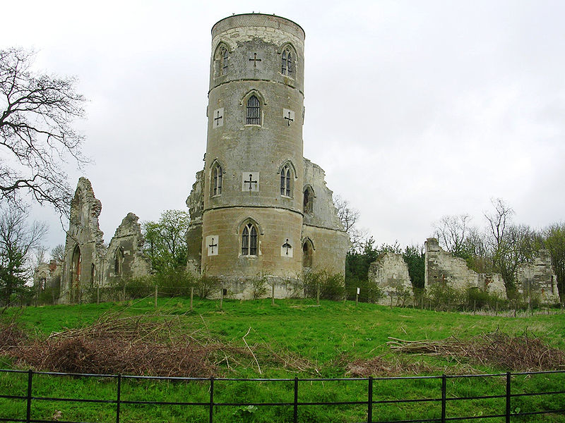
Finally at the top. I could stop and play, but I'm more into heading on, losing two-thirds of that gained height over a short mile or so at up to 35mph. Anyway, this is what the folly looks like.


Wimpole Folly


The Three Cams

Well, I hit the local plain floor and head towards my food stop in Orwell. The roads here do have some traffic, but most are having a pleasant day at Wimpole Hall and are in no mood to rush around in a bad temper. They are much more likely to pass wide, clear, and going a lot slower. Crossing the A604 is not so easy. Again there's a useful side path, but it's not designed for pedestrians and bikes, so I move to the road quite quickly, despite the 60mph cars. I'm sure they could do better for the short 200 yards that it's needed.


View A604 larger

Still, once past that, the centre of the village of Orwell is very pretty. I have a bit to eat to keep energy levels up.


Food stop at Orwell Church

And a summer pass showing a Pannier Market!

So, onto the Three Cams. Well, a bit of license here, but these three rivers define the shape of the valleys up water from Cambridge. They all flow through Cambridge as the river Cam. The Rhee and the Granta meet at Hauxton Junction just above Byron's Pool. Just up the Granta branch it amalgamates two rivers again, this time called the "river Granta or Cam" and the "river Granta". Wikipedia has the orginal name for Cambridge as "Grantebrycge", hence the river name.Thus the 3 rivers above Cambridge have 3 names, but 2 names can mean 2 different rivers. Hmm, give me calculus....

The river Rhee goes through the villages to the west all the way up to Ashwell just in Hertfordshire. This is the first river I'll cross, just after Barrington. I notice that my speed on the road is much quicker than the previous track experiences, but then I cross the Rhee and my speed drops! Even what looks to be flat around here, isn't so much. Do note that people here call the river the Cam. Hmm.

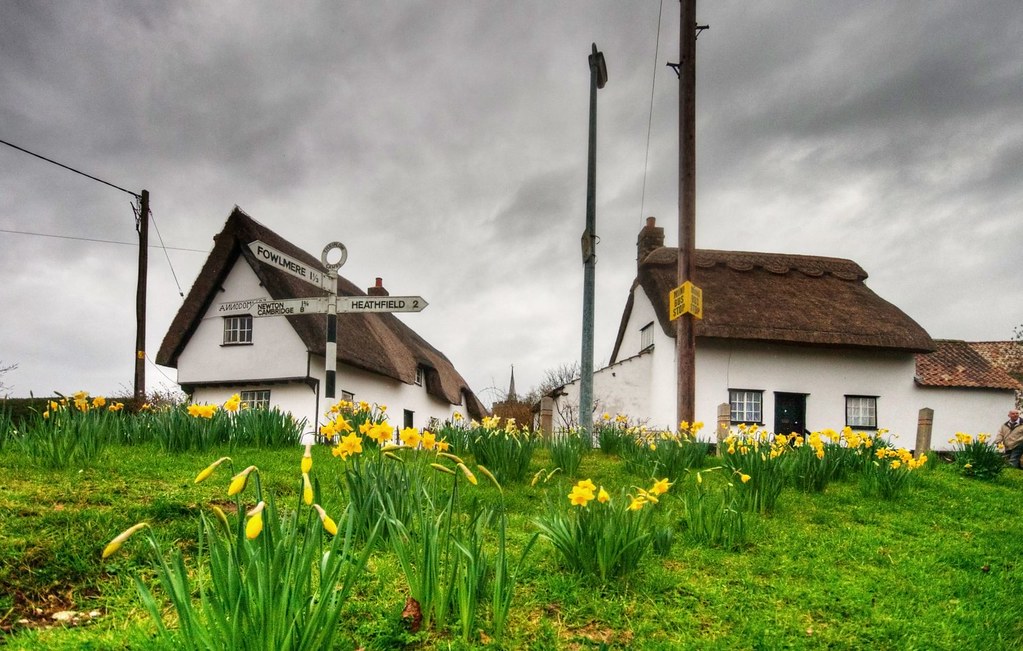
Just after that I have the first level crossing experience. Luckily not a long wait, unlike the Tour de Suisse the day after!  The villages of Shepreth, Fowlmere, and Thriplow are all pretty, the latter especially during it's daffodil festival. The roads between are fast but dull, barring the horrible crossing of the A10.


Daffodil festival by Rouguesgallery17 on Flickr.


In Thriplow, taking a back lane finds the recently upgraded Drift Track. It's now a bridleway, so open to people cycling and is a convenient way to get to Whittlesford.

In Whittlesford, a local footpath has been converted to a new cyclepath to the large village of Sawston. This is mostly to do with school children, as the latter has big schools for the local area. There is some concern about the lack of signage for this path. And you see that I don't take this route. I've always found Church Lane more pleasant, although this isn't the main route and again is confusing with the signage.


Photo from cyclestreets.net looking back towards Whittlesford.

A certain amount of amusement can be had from the "Slow Pedestrians Ahead" signs with the lack of comma after "Slow". But it is a massive improvement on the "Cyclists Dismount" sign, which is it's equivalent. Just to note, the "Cyclists Dismount" sign is not an instruction/order (it's a blue sign) it is a request.There have been a number of campaigns against the misleading wording of it.

At the end of this path is the crossing of the "river Cam or Granta", altogether more pleasant than the crossing of the Rhee. This river is the biggest of the three and goes up beyond Audley End. My Saffron Walden route covers this well. I canoed down from above here the Easter when I was 11. I got wet, and during overnight camping, it froze. Needless to say, not the happiest experience.

Anyway, the second level crossing experience happened just after this. Again, not a long wait. After the crossing, there was a distinct lack of signage. The route actually goes to the right of the road and onto the pavement. But that's not clear, there are no signs.

In Sawston the cyclepath quickly disappears. This wasn't too much of an issue on a Sunday afternoon. I just wonder what schoolchildren experience going along this road at just before 9am on a weekday, at the same time as many, possibly rushing, people driving?

Again in Sawston the signage is a bit lacking. A route continues on the pavement up north from the main crossroads. It's not easy to get onto it if you've missed the previous dropped kerb with the only nearby drop right at the lights. This route north isn't too bad. It is a bit thin, a bit rough at times, and has some unnecessary conflict with bus passengers. It's better than being on the road here, though.

When rejoining the A1301 it does the most ridiculous route. It actually crosses one more road than necessary. Why?!

Extra unnecessary road crossing in less sunny times from cyclestreets.net.

It then does these series of close wiggles designed to slow people cycling down. Of course, the result is lots of off-road cuts where people cycling have just given up and smoothed the corners. I guess the principle is that theyy should slow down to stop before crossing the more dangerous A1301. And, given people driving blast along here at 60mph (and more!), it's possible to understand that point. However, with the clear lines of sight, the loud noise of traffic on the roads, I can't see any person cycling missing the danger of this place.

After this the cyclepath goes into Stapleford. The path is separated from the road, but still narrow and shared with pedestrians. It does have a nice little side route away from the road whilst crossing the "river Granta". However, getting onto this from the other direction is a task, and sharing with pedestrians is not ideal either.

My Photo from cyclestreets.net.

The "river Granta" follows the valley up through Linton to Haverhill. Again, this appears on my Saffron Walden route.

Through Stapleford on route NCN11, up Church Street and along Mingle Lane, passing the village church.

View Larger picture

Then onto the Addenbrookes cycle path and south Cambridge Guided Buway Cyclepath, which I've written about before!

Full Video Clip


This shows the full trip at 8 times speed. Key points are as follows.

00:13 Cross Hills Road
00:28 The Coe Fen
01:27 West Cambridge Cyclepath
02:44 Off-roading from Coton
03:31 Permissive bridleway
06:42 Kingston village
08:44 Wimpole Folly top
09:32 A604 path for people cycling?
09:57 Food stop in Orwell
10:55 Barrington
11:09 Crossing river Cam or Rhee
11:29 Level crossing
13:36 The Drift
15:19 Whittlesford Cyclepath
16:28 Pointless road crossing and slalom
16:43 Crossing "river Granta"
17:19 Addenbrookes Cyclepath
18:02 South Cambridge Guided Buway Cyclepath


Friday, 8 June 2012

River Cam and Green Lanes

an exploration up NCN11 and look at some off-road routes near Cambridge

Several parts to this post.


NCN11 Disconnect

Going north-east up National Cycle Network Route 11 from Cambridge, there's a break in the route. It follows the river Cam up to Waterbeach then disappears to re-appear about 2 miles south-east heading up to Wicken Fen in a parallel fashion. Between these two ends, there are a few paths and two river crossings at Clayhithe and Bottisham Lock.


View River Cam and Green Lanes in a larger map

This little trip and video clip was partly an investigation into that gap which has 2 obvious solutions.
  • A simple route from the Clayhithe road bridge would be to convert a private road, Hatridge's Lane to Northfields Farm, and cut the short distance through to Vicarage Farm on Lug Fen Droveway (which is already a public footpath). Then the route would go south-east along Lug Fen Droveway, a public road, until it met up at White Fen Drove.
  • The proposed NCN11 route would be fromWaterbeach railway station car park, where the route currently ends, alongside ht railway north-east, then along Burgess Drove and turning down to Bottisham Lock. Crossing the river, turning along the bank paths until Bottisham Lode then coming along the west side Bottisham Lode until Lug Fen Droveway again.

It looks like both routes are experiencing some opposition, maybe from the landowners, maybe not.

Hatridge's Lane is private, although there are public footpaths that do a similar route, a few dozen yards away. "Private" signs are clear, which can simply be the landowner not wanting people to accidentally come this way, of course.


View picture larger

This route has probably the least impact and least building costs involved. However, it's not the proposed option.

Starting opposite Waterbeach railway station car park looks better to begin with. This is already a public footpath, has space, and in semi-public ownership.


View picture larger

However, looking at the below video clip, Burgess Drove quickly deteriorates and would need some work, especially as it's quite well used by other vehicles.

Then Bottisham Lock is a very narrow crossing currently with steps. That would not work with larger or loaded bikes.


Then, when approaching Bottisham Lode there's clear signs of antipathy towards cycling. Or possibly simply trying to stop the tide. I'm sure many cyclists don't know what to do when getting to the end of NCN11 and just try pushing through. Anyway, here's the signs on both routes on.


Photo from cyclestreets.net.


The latter photo is the proposed route down to Lug Fen Causeway where the path quickly joins the public road across a bridge.


View picture larger


So which route should the NCN11 try to take to join up? My preference would be neither.  Although I'd start along the Bottisham Lock route, I'd much prefer to continue up the river to Upware, then cut back at a better angle to Wicken Fen. However, much has already been done to bring the route through to Lug Fen Causeway that would make that a very unlikely option!

Food stop at Swaffham Bulbeck Lode.


Anglesey Abbey Parking

Later on my route, I found myself wondering why the residents of Lode had so many cars. Suddenly, it clicked. This was overflow from the Anglesey Abbey country house run by the National Trust.


My photo from cyclestreets.net


I did clip about this separately as I thought it quite awful. As I say on the clip:
  • The sheer volume of parking inadequately, some illegally, most disruptive to the local village, and pretty much all causing a blot on the landscape, Anglesey Abbey should hang it's head in shame.
This is within a mile of a good off-road cycleroute from Cambridge. So, rather than spending money building more parking space and concreting over the country yet further, why not invest the same in a decent off road route as a public donation? There's plenty of space and I bet many people visiting would rather have the family outing in more pleasant environment of being on a bike.


Green Lanes

The second part of this trip and video clip, was to look at the green lanes that straddle the space between the fens lodes and the hills to the south east. This has some history as it was the route that tribes to the north-east, like the Iceni, would travel down to the south west, and to the Icknield Way. Fleam Dyke was one the the defenses put up in harder times.

Out from Bottisham on the High Street, there's a short stretch of the A1303 to negotiate. It's unpleasant but is a large road with very clear sight lines. Cars still shoot past far too quickly, mostly as they have no idea of what the impact of their car is at such high speed whilst cocooned in a padded saftey cell. But it's only a short distance. Plenty of space for an off-road cyclepath though!


View picture larger

The turn off the A1303 is a little unwelcoming but battle on through the scrapyard, the overrun tarmac bridge over the A14, and there's a pleasant track quite soon.

The clip shows this bit best. The first bit is a quiet lane leading towards the Westley and Dullingham in the villages along the hill tops. Again, this offers a great way of getting between these places without having to go anywhere near main roads. The route is shown as the now defunct "road used as a path". It's clearly been blocked from motorised vehicles, so drops to being a bridleway.

The second section is perpendicular to the first and provides a way of getting from Newmarket to the Wilbrahams and the on into Cambridge.


Full Video Clip

This shows the full trip at 8 times speed. Key points are as follows.

00:00 Through Town from the Station
00:54 Along Riverside
01:27 NCN11 on river path
03:33 Clayhithe Bridge
03:49 End of NCN11 at Waterbeach railway station
04:20 Burgess Drove
04:50 Bottisham Lock
05:10 Warning signs
07:03 Food stop
08:05 New part of NCN11
09:25 Anglesey Abbey Parking
10:15 Turn onto A1303
10:45 Green lane to Westley
11:34 Green lane to Wilbraham
14:30 Bad pass in other clip